History of the Canyon
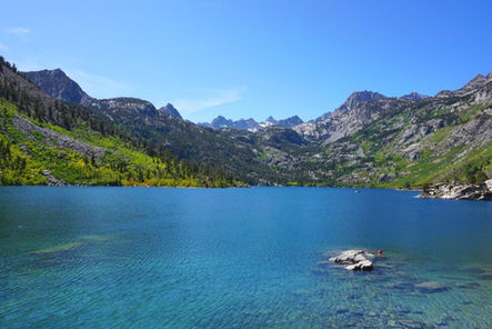
Lake Sabrina was named for Sabrina Hobbs, whose husband, Charles M. Hobbs, was the first general manager of the Nevada California Power Company, which dammed the lake during 1907-1908. Built primarily to hold back the spring run-off and thus for flow regulation for the Bishop Creek Hydroelectic System, the BCHS is considered significant for it's roll: (1) in the expansion of hydroelectric power generation technology, (2) in the development of eastern California and (3) in the development of long-distance electrical power transmission and distribution.
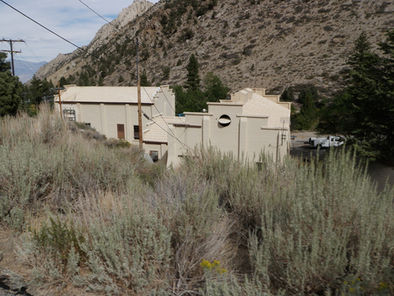
The Bishop Creek Hydrolectric System consists of five sets of independent, high-head-impulse water wheel, electrical power-generating sub-systems (plants) established at various elevation along the north, middle and south forks of Bishop Creek on the eastern slopes of the Sierra Nevada Mountains, Inyo County, California. Five powerhouses, one control station, two guaging stations, ten flowlines, ten intakes, seven penstocks, four diversions, four resevoirs, four dams, worker housing and other associated support buildings make up the system structures. Lake Sabrina, the most distant resevoir is located approximately eighteen miles southwest of Bishop.
Bishop Creek is a run-of-the-river type system whereby stream water is diverted at various points, transported through flowlines at a gradient far less than the stream channel, and ultimately dropped this elevational distance through penstocks, or pressure pipes, down to the impulse wheels in the powerhouses.
The headwater of the South Fork of Bishop Creek are confined in Bluff Lake and South (Hillside) Lake. Lake Sabrina impounds water from the Middle Fork of Bishop Creek, and Longley Lake collects a portion of the McGee Creek flow that is diverted into the Bishop Creek System. The reservoirs of Bishop Creek all collect and store snow-melt from the high Sierra crest keeping it ready for release when needed. Thus, water stored during high flow, which is usually during winter and spring, can be release during summer and fall low flow periods.
Waters from Green Creek and Bluff Lake are diverted to South Lake on the South Fork of Bishop Creek. From the South Fork Dam to Coates Meadow (a distance of seven and one half miles), the stream travels the natural channel toward its confluence with the Middle Fork. The South Fork Bishop Creek dam and flowline diverts a portion of this water from Coates Meadow around the east end of Table mountain into a stablizing resorvoir (Intake2). Water from Lake Sabrina flows the natural channel from the dam outlet into Intake 2 (a distance of approximately four miles). Waters from Birch and McGee creeks enter the system below Intake 2.
From this point on, the water transportation pattern is repeated from plant to plant: water is taken from an intake or equalizing pond and tranported via flowlines and penstock to the next plant. In this way, the water of Bishop Creek is used five times on it's journey down the steep canyon to the edge of Owens Valley. From Intake 2 to the tailrace at Plant 6 the water drops 3,590 feet. After leaving Plant 6, the water is used for irrigation before final disposition into the Owens River.
For most of its history, Bishop Creek was a fairly remote place, and as initially conceived, the electrical generators of the Bishop Creek System required the constant presence of operators. The need for large operator/maintenance crews coupled with the remote location led to the development of communities of worker housing around the plants. By the 1960s, two things occured that portended irretrievable change to the character of worker life on the Bishop Creek System. First, in 1965-66 a new two lane all weather highway (new Highway 168) was constructed between Bishop and Lake Sabrina. Old Highway 168 (the County Road) was the through access road for the Bishop Creek Hydroelectric System; it passed directly through the community of worker housing and operating headquarters surrounding Plant 4. Sections of this road, especially those between Plants 3 and 4, were one lane with no turnouts. The new Highway 168 is an all-weather two lane road with wide shoulders and minimal curves that completely bypasses the treacherous parts of the old road between Plants 3 and 4. This new road provides a much quicker and safer commute between the town of Bishop and the Bishop Creek facilites, and prompted many of the System workers to relocate to Bishop where schools, shopping and other "urban" amentites were available. Also about this time, measures to enable a more automated System operation were intiated; these changes would eventually lead to the 1994 Eastern Automation Project. The new road and the move toward automation combined to eliminate the need for worker housing at the powerhouses, and in 1978-79 houses at Plants 2, 3, and 5 were removed. A substantial community of worker housing is still present at Plant 4 along with most of the System operations headquarter offices and support facilites. A smaller community of wokrer housing is present at Control Station, and a single home is present at Plant 6.
Although numerous additions, modifications, and deletions of ancillary structures have occured, the Bishop Creek System looks and operates much as it did in 1913 when the last powerhouse (Plant 6) was completed. Some modification to the exterior appearance of several of the powerhouses, and replacement of the original wood-stave flowlines has also ocurred.
The visual character of the System owes much to the dramatic backdrop of the eastern Sierra Nevada Mountains and the glaciated terrain of Bishop Creek. The System itself is less visible to the visiting public because most of the more interesting buildings were nestled down in the canyon adjacent to Bishop Creek and have been bypassed by the new highway. Nevertheless, the System is now an integral paret of the local landscape and remains today an useful power generation contributo the the Southern California market.
Lake Sabrina was drained in the Fall of 2004 so the outflow structure at the northeast end of the dam could be rebuilt. In the Spring of 2006, the lake was once again empty so redwood facing could be covered with a pvc membrane to prevent leakage


